La Pampa
Explora Nuestras Provincias y sus Riquezas is part of Argentina al Mundo, alongside Argentine Delights, Guía AD-Gourmet and Chefs Argentinos al Mundo.
La Pampa, land of endless horizons. Where the plains meet the caldén forest, a tree that grows only in Argentina, and the steppe opens toward Patagonia. In Lihué Calel, pink hills hold ancient paintings, and every autumn the roar of the red deer echoes through Parque Luro. A Ranquel land, of fields, horses and noble people. Beef, honey and the voice of Alberto Cortez. La Pampa is not rushed: it is contemplated. La Pampa is the biggest sky in Argentina.


Political map · Source: IGN
- Capital
- Santa Rosa
- Region
- Pampas
- Area
- 143,440 km²
- Population · 2022 Census
- 361,859 inhabitants · 2.5 hab/km²
- Women · Men
- 50.8 % · 49.2 %
- Median age
- 34 years
- By age
- 0 to 14 years: 21.5 % · 15 to 64 years: 65.5 % · 65 years and over: 13.0 %
- Climate
- Subhumid temperate in the east; semi-arid to arid towards the west.
- Demonym
- pampeano/a
- Founding of the capital
- 22 April 1892
- Status
- Province since 1951 · Ley 14.037
- Departments
- 22
- Born in another province · abroad
- 21.0 % · 1.0 %
Sources: INDEC, 2022 National Census (final results) · INDEC / IGN (area) · Provincialization laws · IGN (political division).
- Mean annual temperature
- 15.7 °C
- Annual rainfall
- 753 mm
- Mean maximum · warmest month
- 31.5 °C · January
- Mean minimum · coldest month
- 2.1 °C · July
Source: Servicio Meteorológico Nacional (SMN), climatological standard normals 1991–2020, station Santa Rosa Aero, submitted to the World Meteorological Organization.
- Main rivers
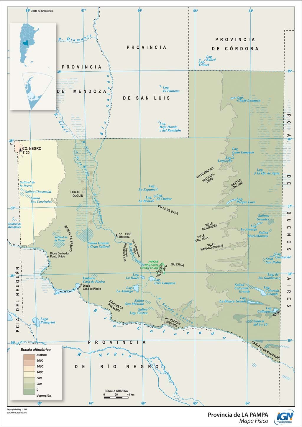
- Colorado · Salado-Chadileuvú · Atuel
- Ecoregions
- Espinal · Pampas · Monte of Plains and Plateaus
- Main cities
- Santa Rosa · General Pico · Toay · General Acha · Realicó
Sources: Secretaría de Infraestructura y Política Hídrica de la Nación, river basins · Ministerio de Ambiente de la Nación, ecoregions of Argentina · INDEC, 2022 National Census (population by department).
- Provincial flower
- Pampas daisy · Ley 1.774 (1997) · endemic to the hills of south-central La Pampa
Sources: Gobierno de La Pampa.
- Hotel guests · 2024
- 118,516 in Santa Rosa · 5.2 % from abroad
- National park
- Lihué Calel
Sources: INDEC and Secretaría de Turismo de la Nación, Hotel Occupancy Survey (hotels and other lodgings) · Administración de Parques Nacionales.
- Airport
- Santa Rosa · 41,625 passengers in 2025
- Scheduled flights · 2025
- Aeroparque 41,625 passengers
- National routes
- RN 5 · RN 22 · RN 35 · RN 143 · RN 151 · RN 152 · RN 154 · RN 188 · RN 232
Sources: Secretaría de Turismo de la Nación, Air connectivity, with ANAC data · Instituto Geográfico Nacional (IGN), national road network and international crossings.
- From Santa Rosa to the City of Buenos Aires, by road
- 620 km
To the other provincial capitals, by road
- San Luis 505 km
- Neuquén 537 km
- Viedma 594 km
- Córdoba 600 km
- La Plata 670 km
- Mendoza 765 km
- Santa Fe 810 km
- San Juan 825 km
- Paraná 841 km
- Rawson 855 km
- Santiago del Estero 1,030 km
- La Rioja 1,035 km
- San Fernando del Valle de Catamarca 1,040 km
- San Miguel de Tucumán 1,190 km
- Corrientes 1,378 km
- Resistencia 1,475 km
- Salta 1,497 km
- Formosa 1,523 km
- San Salvador de Jujuy 1,530 km
- Posadas 1,660 km
- Río Gallegos 2,035 km
- Ushuaia 2,628 km
Source: Government of the Argentine Republic (argentina.gob.ar), road distances between provincial capitals.
- National festivals
- Festival Nacional de Doma y Folklore · January and February · Intendente Alvear
Fiesta Nacional de la Ganadería del Oeste Pampeano · February · Victorica
Sources: Res. Secretaría de Turismo de la Nación 244 · argentina.travel.
- Share of the national economy · 2024
- 1.0 % · rank 18 of 24
- Growth 2004–2024
- +61 % · the country, +42 %
- Main activities
- Trade 26.0 % · Agriculture and livestock 20.3 % · Public administration 7.3 % · Oil and gas 6.4 %
Source: ECLAC and Ministerio de Economía de la Nación, Provincial breakdown of gross value added, 2004 base (2023 and 2024, preliminary data).
Natural wealth
The territory that defines it
La Pampa is the transition between the humid plains and Patagonia. To the east, fields of wheat, sunflower and pasture; in the center, the caldenal, the caldén forest, a tree that exists only in Argentina; to the west, the steppe, the salt flats and the dunes. Lihué Calel National Park, "mountain of life" in the Mapuche language, holds pink granite hills and rock paintings in the middle of the plain. Near Santa Rosa, the Parque Luro Provincial Reserve protects the caldenal and is the stage, every autumn, for the rut of the red deer.
- Parque Nacional Lihué Calel (1976)
Source: Argentine National Parks Administration (SIB-APN).
Human wealth
The living figures
La Pampa is a land of open horizons and of a Ranquel heritage that its communities reclaim today. Its country towns keep the culture of the caldén, the horse and rural work. At the table, beef from its herds, deer and wild boar from the forests, kid goats from the west and honey from its fields.
- Before the conquest · the Ranquel, a people of the plains, have the center of their territory at Leubucó, near Victorica
- 1870 · Lucio V. Mansilla visits Leubucó and writes An Expedition to the Ranquel Indians, a classic of Argentine literature
- 1879-1884 · military campaigns incorporate the territory into the national State; in 1884 the National Territory of La Pampa is created
- 1892 · Santa Rosa, today the provincial capital, is founded
- 1951 · La Pampa becomes a province
Sources: Government of La Pampa · National Library.
- Alberto Cortez · music · born in Rancul (1940-2019), a singer-songwriter of international reach
Sources: careers published in national and international press.
15,659 people identify as Indigenous or as descendants of Indigenous or native peoples: 4.4 % of the province's population. They belong to 36 different peoples, and 1,485 (9.5 %) speak or understand the language of their people. The five largest peoples are:
- Ranquel · 5,326
- Mapuche · 2,474
- Mapuche Tehuelche · 416
- Guaraní · 342
- Tehuelche · 253
Source: INDEC, 2022 National Population, Household and Housing Census, final results. Population in private dwellings.
Productive wealth
What it produces and exports
La Pampa lives from the land: cereals and oilseeds in the east, cattle breeding and fattening that supplies export meatpackers, and honey as a traditional product. In the west, oil from the 25 de Mayo area completes its economy. China is today its main export destination.
USD 939 million, 3.7 % less than in 2024: 1.1 % of the national total and 1.5 % of the Pampas region.
- Primary products · USD 669 M
- Manufactures of agricultural origin · USD 221 M
- Fuels and energy · USD 40 M
- Manufactures of industrial origin · USD 9 M
Main destinations: China (USD 190 M, 20.2 %), Middle East (USD 134 M), European Union (USD 114 M) and Peru (USD 55 M). Main products: cereals (USD 463 M), meat and meat preparations (USD 207 M), oilseeds and oleaginous fruits (USD 182 M) and crude oil (USD 40 M).
Source: INDEC, Provincial origin of exports. Goods. Year 2025 (provisional data) and annex tables.
2,966,676 head as of 31 December 2024: 5.7 % of the national cattle stock. Meat was its second export product in 2025, with USD 207 M.
Sources: SENASA, stock as of 31/12/2024, in Secretariat of Agriculture, Provincial cattle profile 2024 · INDEC, Provincial origin of exports 2025.
CONICET has two research units in the province, together with the Universidad Nacional de La Pampa.
Source: CONICET, 2025 Management Report.
Data on mining and hydrocarbons is included for information purposes only, as part of the province's productive profile. Explora Nuestras Provincias y sus Riquezas does not promote extractive activity.
Space to embed one or more 45s–1min capsules about the province.
To experience it on the ground — restaurants, hotels, events, geolocation — the app.
Open the Argentina al Mundo app