Río Negro
Explora Nuestras Provincias y sus Riquezas is part of Argentina al Mundo, alongside Argentine Delights, Guía AD-Gourmet and Chefs Argentinos al Mundo.
Río Negro, from the Andes to the sea. In Bariloche, Nahuel Huapi reflects snow-capped mountains and ancient forests, and from Cerro Catedral and Cerro Otto Patagonia unfolds at your feet. Further south, El Bolsón, among farms, hops and artisans. A river crosses it from end to end, irrigating the Alto Valle of apples and pears, until it reaches the sea at Las Grutas. Chocolates, craft beers and the talent of INVAP that reaches space. Río Negro is not toured: it is lived in every season. Río Negro is all of Patagonia in a single province.

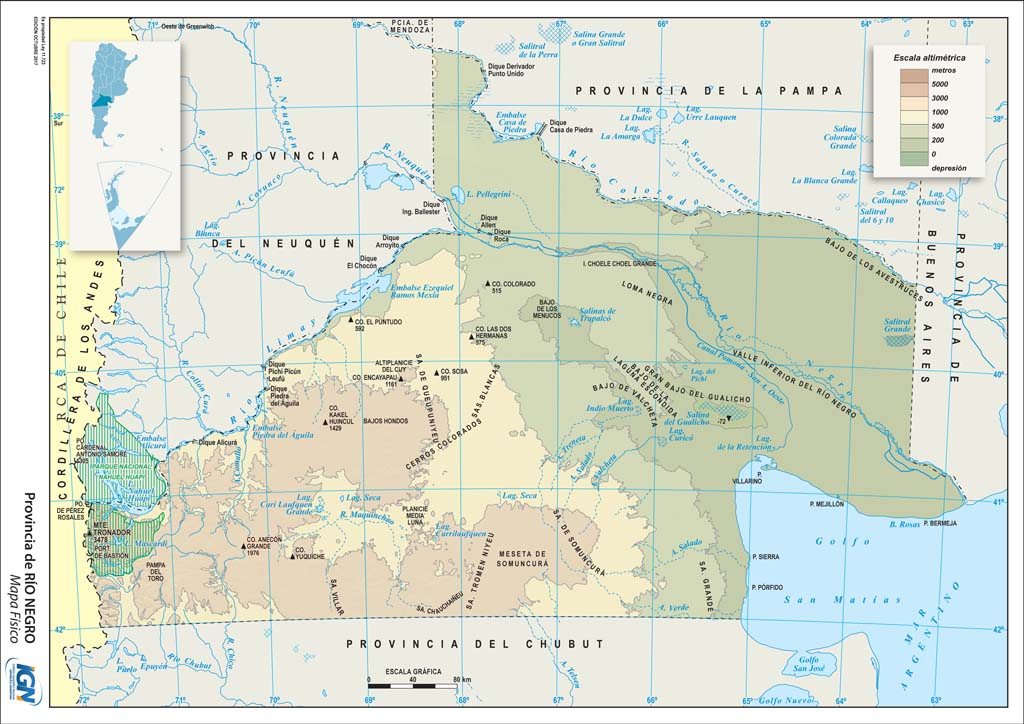
Political map · Source: IGN
- Capital
- Viedma
- Region
- Patagonia
- Area
- 203,013 km²
- Population · 2022 Census
- 750,768 inhabitants · 3.7 hab/km²
- Women · Men
- 51.1 % · 48.9 %
- Median age
- 33 years
- By age
- 0 to 14 years: 22.0 % · 15 to 64 years: 66.9 % · 65 years and over: 11.1 %
- Climate
- Arid on the plateau; temperate in the valleys; cool temperate and humid in the Andes.
- Demonym
- rionegrino/a
- Founding of the capital
- 22 April 1779
- Status
- Province since 1955 · Ley 14.408
- Departments
- 13
- Born in another province · abroad
- 25.0 % · 5.5 %
Sources: INDEC, 2022 National Census (final results) · INDEC / IGN (area) · Provincialization laws · IGN (political division).
- Mean annual temperature
- 14.3 °C
- Annual rainfall
- 383 mm
- Mean maximum · warmest month
- 29.6 °C · January
- Mean minimum · coldest month
- 1.4 °C · July
Source: Servicio Meteorológico Nacional (SMN), climatological standard normals 1991–2020, station Viedma Aero, submitted to the World Meteorological Organization.
- Highest point
- Cerro Tronador · 3,478 m · on the border with Chile
- Main rivers
- Negro · Limay · Colorado
- Ecoregions
- High Andes · Patagonian Forests · Patagonian Steppe · Monte of Plains and Plateaus
- Main cities
- San Carlos de Bariloche · General Roca · Cipolletti · Viedma · Allen
Sources: Administración de Parques Nacionales (APN), Parque Nacional Nahuel Huapi · Secretaría de Infraestructura y Política Hídrica de la Nación, river basins · Ministerio de Ambiente de la Nación, ecoregions of Argentina · INDEC, 2022 National Census (population by department).
- Provincial natural monuments
- Huemul · Ley 2.646 (1993)
Naked characin · Ley 2.783 (1994)
Southern right whale · Ley 4.066 (2006)
Sources: Legislatura de Río Negro.
- Hotel guests · 2024
- 818,624 in the surveyed towns: San Carlos de Bariloche 738,704 · Las Grutas 50,037 · Viedma 29,883 · 31.4 % from abroad
- National parks
- Nahuel Huapi · Islote Lobos
Sources: INDEC and Secretaría de Turismo de la Nación, Hotel Occupancy Survey (hotels and other lodgings) · Administración de Parques Nacionales.
- Airports · passengers 2025
- Internacional Teniente Luis Candelaria 2,502,973 · Gobernador Castello 34,154
- Scheduled flights · 2025
- Aeroparque 1,313,621 · Ezeiza 775,743 · Córdoba 138,356 · Mendoza 77,264 passengers
- National routes
- RN 3 · RN 22 · RN 23 · RN 40 · RN 151 · RN 232 · RN 237 · RN 250 · RN 251
- International border crossings
- Chile 3
Sources: Secretaría de Turismo de la Nación, Air connectivity, with ANAC data · Instituto Geográfico Nacional (IGN), national road network and international crossings.
- From Viedma to the City of Buenos Aires, by road
- 960 km
To the other provincial capitals, by road
- Rawson 495 km
- Santa Rosa 594 km
- Neuquén 660 km
- La Plata 957 km
- San Luis 1,099 km
- Córdoba 1,194 km
- Mendoza 1,359 km
- Santa Fe 1,404 km
- San Juan 1,419 km
- Paraná 1,435 km
- Santiago del Estero 1,624 km
- La Rioja 1,629 km
- San Fernando del Valle de Catamarca 1,634 km
- Río Gallegos 1,675 km
- San Miguel de Tucumán 1,784 km
- Posadas 2,000 km
- Corrientes 2,046 km
- Resistencia 2,069 km
- Salta 2,091 km
- Formosa 2,117 km
- San Salvador de Jujuy 2,124 km
- Ushuaia 2,268 km
Source: Government of the Argentine Republic (argentina.gob.ar), road distances between provincial capitals.
- National festivals
- Fiesta Nacional de la Manzana · February · General Roca
Fiesta Nacional de la Nieve · August · San Carlos de Bariloche
Sources: Decreto nacional 1.580/1971 · Res. Secretaría de Deportes y Turismo de la Nación 145/1979 · Ley provincial 360.
- Share of the national economy · 2024
- 1.4 % · rank 13 of 24
- Growth 2004–2024
- +45 % · the country, +42 %
- Main activities
- Trade 15.1 % · Public administration 8.4 % · Oil and gas 7.4 % · Public education 6.3 %
Source: ECLAC and Ministerio de Economía de la Nación, Provincial breakdown of gross value added, 2004 base (2023 and 2024, preliminary data).
Natural wealth
The territory that defines it
Río Negro crosses Patagonia from the Andes to the sea, and along the way it brings together very different landscapes and climates. The Andean region, of lakes, forests and snow-capped mountains, with Bariloche and El Bolsón. The Línea Sur, the great steppe plateau of herders and merino sheep. The Alto Valle and the Valle Medio, fruit-growing oases irrigated by the Limay, Neuquén and Negro rivers. And the Atlantic coast of the San Matías Gulf, with Las Grutas, mild beaches and marine wildlife that includes Islote Lobos National Park.
- Parque Nacional Nahuel Huapi (1934)
- Parque Nacional Islote Lobos (2022)
Source: Argentine National Parks Administration (SIB-APN).
- Lake Nahuel Huapi · heart of Nahuel Huapi National Park, created in 1934 from lands donated by Perito Moreno: the country's first national park
- Cerro Catedral · one of the largest ski resorts in South America
- Cerro Otto and Cerro Campanario · viewpoints over the lakes, with cable car and chairlift
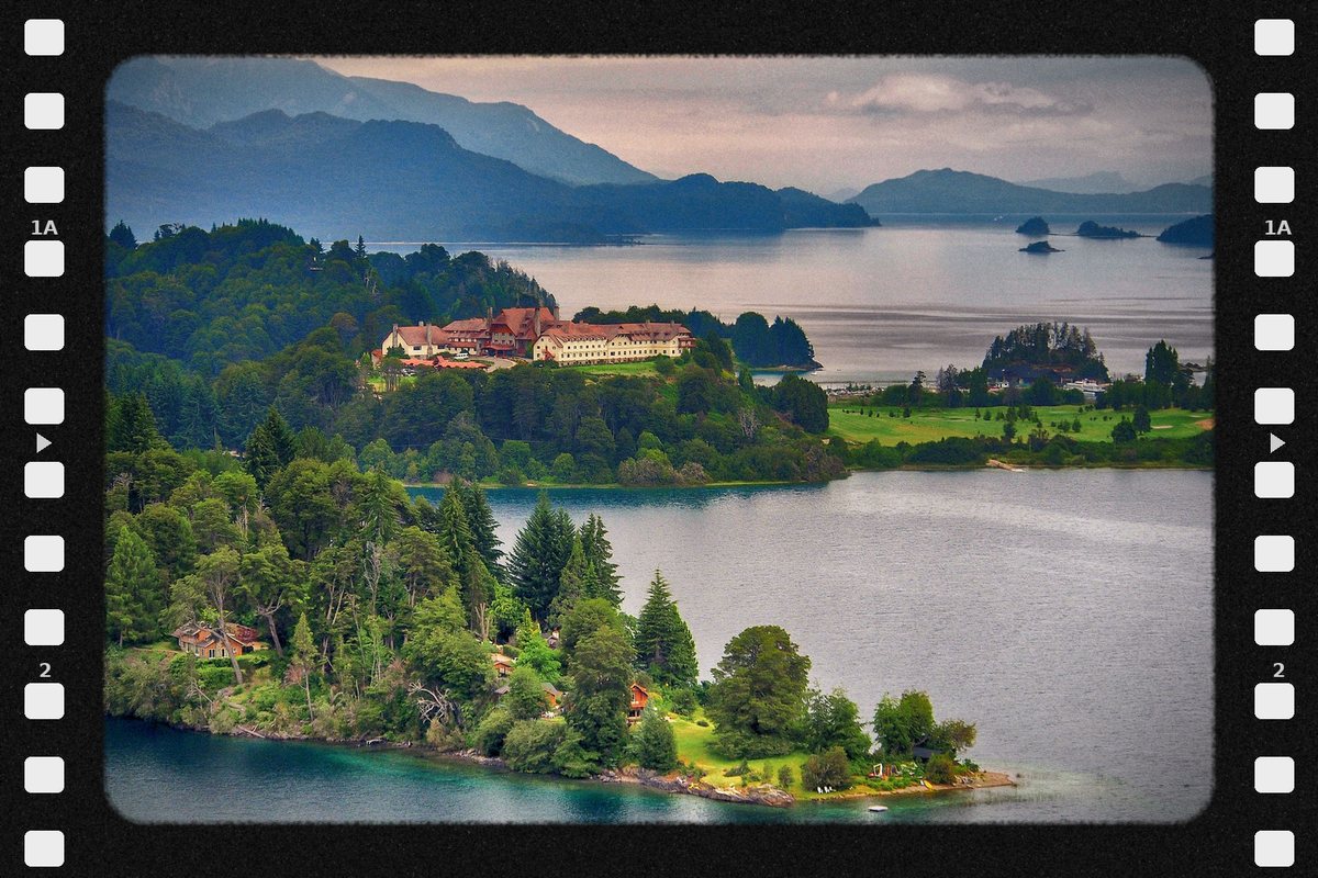
- Circuito Chico, Llao Llao, Isla Victoria and Puerto Blest · the great lake excursions; the Llao Llao hotel and the Civic Center, works by Alejandro Bustillo, are icons of mountain architecture
- Cerro Tronador · glaciers and waterfalls on the border with Chile
Bariloche celebrates the National Snow Festival and the National Chocolate Festival, a craft that arrived with Central European immigration and is today one of its trademarks.
Sources: Argentine National Parks Administration · Municipality of San Carlos de Bariloche.
South of Bariloche, in a valley between snow-capped ranges, El Bolsón is a land of farms, berries, craft breweries and its famous regional artisans' fair. Cerro Piltriquitrón and the Azul River frame one of the most singular areas of Patagonia. Every February it celebrates the National Hops Festival.
Sources: Municipality of El Bolsón · Government of Río Negro.
- Las Grutas · on the San Matías Gulf, with some of the mildest waters of the Argentine Sea
- Balneario El Cóndor · its cliffs host a colony of burrowing parrots considered the largest in the world
- Islote Lobos National Park · created in 2022, it protects sea lions, shorebirds and wetlands of the gulf
Sources: Argentine National Parks Administration · CONICET · Government of Río Negro.
Human wealth
The living figures
Río Negro is one of the country's top tourist provinces: Bariloche welcomes travelers from all over the world every year and is the great destination for graduation trips. Its identity combines the Mapuche and Tehuelche heritage, the culture of the valley's fruit farmers, children of Italian and Spanish immigration, and the Central European imprint of the mountains. At the table, chocolates, craft beers, smoked foods, berries, Patagonian lamb, trout, and pears and apples from the valley.
- Before the conquest · the Tehuelche and Mapuche roam the plateau, the valleys and the mountains
- 1779 · Francisco de Viedma founds the Fuerte del Carmen, the origin of Viedma, the current capital, and of Carmen de Patagones
- 1879-1885 · military campaigns incorporate the territory into the national State
- 1902 · San Carlos de Bariloche is founded, driven by settlers of German, Swiss and Chilean origin
- 1955 · Río Negro becomes a province
Sources: Government of Río Negro · Municipality of San Carlos de Bariloche.
48,194 people identify as Indigenous or as descendants of Indigenous or native peoples: 6.4 % of the province's population. They belong to 44 different peoples, and 8,213 (17.0 %) speak or understand the language of their people. The five largest peoples are:
- Mapuche · 30,173
- Mapuche Tehuelche · 4,333
- Tehuelche · 2,083
- Guaraní · 787
- Quechua · 632
Source: INDEC, 2022 National Population, Household and Housing Census, final results. Population in private dwellings.
Productive wealth
What it produces and exports
Río Negro's economy combines fruit growing in the Alto Valle, mountain tourism, sheep and cattle farming, fishing in the San Matías Gulf and oil, which is growing with Vaca Muerta. To that it adds a technology hub of global reach in Bariloche. The United States is today its main export destination.
USD 670 million, 11.4 % more than in 2024: 0.8 % of the national total and 5.3 % of Patagonia.
- Primary products · USD 326 M
- Fuels and energy · USD 221 M
- Manufactures of agricultural origin · USD 117 M
- Manufactures of industrial origin · USD 7 M
Main destinations: United States (USD 221 M, 33.0 %), Brazil (USD 154 M), Chile (USD 82 M) and European Union (USD 47 M). Main products: fresh fruit (USD 298 M), crude oil (USD 208 M), vegetable, pulse and fruit preparations (USD 70 M) and sugar, cocoa and confectionery (amount withheld for statistical confidentiality).
Source: INDEC, Provincial origin of exports. Goods. Year 2025 (provisional data) and annex tables.
Public sector · Río Negro contributes 70 % of the apples and pears produced in the country, and more than 80 % of the pears, with about 19,800 hectares of pear orchards. Argentina is the world's second exporter of pears. Fresh fruit was its leading export in 2025, with USD 298 M.
Sources: Government of Río Negro, Secretariat of Fruit Growing · INDEC, Provincial origin of exports 2025.
Río Negro is the country's leading hop-producing province: 80 % of its production is concentrated in El Bolsón and the rest in the Alto Valle. El Bolsón accounts for more than half of national production and is the heart of craft brewing in Patagonia.
Sources: Government of Río Negro · hop growers of the Comarca Andina.
Bariloche is home to INVAP, the Río Negro state technology company that built research nuclear reactors for countries such as Australia, Egypt and Algeria, and satellites such as ARSAT and SAOCOM, and to the Balseiro Institute, created in 1955 alongside the Bariloche Atomic Center, the cradle of physicists and nuclear engineers.
Sources: INVAP · National Atomic Energy Commission · Universidad Nacional de Cuyo.
Crude oil was its second export in 2025, with USD 208 M. The Vaca Muerta Oil Sur pipeline will reach the sea along its coast, carrying Neuquén crude to a new export terminal at Punta Colorada, on the San Matías Gulf.
Sources: INDEC, Provincial origin of exports 2025 · Argentine Ministry of Economy, RIGI.
CONICET has seven research units in the province, together with the Universidad Nacional de Río Negro and the Universidad Nacional del Comahue.
Source: CONICET, 2025 Management Report.
Data on mining and hydrocarbons is included for information purposes only, as part of the province's productive profile. Explora Nuestras Provincias y sus Riquezas does not promote extractive activity.
Space to embed one or more 45s–1min capsules about the province.
To experience it on the ground — restaurants, hotels, events, geolocation — the app.
Open the Argentina al Mundo app